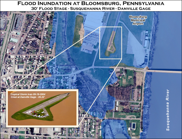
Susquehanna Inundation Maps

The Susquehanna River Basin Commission (SRBC) maintains inundation maps for a number of National Weather Service (NWS) river forecast points across the basin. These maps display expected area of flood inundation that will occur at a specific river stage above flood stage. The maps are available for viewing online, as available, and by request. Available online inundation map libraries can be accessed through the United States Geological Survey and the National Weather Service map viewers (see direct links below). Additional libraries (see “SRBC Map Library” below) can be accessed by sending an email to [email protected] with the property address and preferred format (.jpg, .pdf, .shp) included in the message. SRBC will respond to your request via email.
National Weather Service (Online libraries)
New York
|
|
Site
|
Information Sheet
|
|
Chemung River at Chemung, NY (CMGN6)
|
Information Sheet
|
|
Chemung River at Corning, NY (CRNN6)
|
Information Sheet
|
|
Chemung River at Elmira, NY (CHEN6)
|
Information Sheet
|
|
Chenango River at Chenango Forks, NY (CNON6)
|
Information Sheet
|
|
Chenango River at Greene, NY (GNEN6)
|
Information Sheet
|
|
Susquehanna River at Bainbridge, NY (BAIN6)
|
Information Sheet
|
|
Susquehanna River at Binghamton, NY (BNGN6)
|
Information Sheet
|
|
Susquehanna River at Conklin, NY (CKLN6)
|
Information Sheet
|
|
Susquehanna River at Owego, NY (OWGN6)
|
Information Sheet
|
|
Susquehanna River at Unadilla, NY (UNDN6)
|
Information Sheet
|
|
Susquehanna River at Windsor, NY (WSRN6)
|
Information Sheet
|
|
Susquehanna River at Vestal, NY (VSTN6)
|
Information Sheet
|
|
Tioga River near Erwins, NY (ERWN6)
|
Information Sheet
|
|
Unadilla River at Rockdale, NY (RCKN6)
|
Information Sheet
|
Pennsylvania
|
|
Site
|
Information Sheet
|
| Susquehanna River at Bloomsburg (BMBP1) |
Information Sheet
|
| Susquehanna River at Danville (DANP1) |
Information Sheet
|
| Susquehanna River at Harrisburg, PA (HARP1) |
Information Sheet
|
| Susquehanna River at Sunbury (SBYP1) |
Information Sheet
|
| Susquehanna River at Wilkes-Barre (WBRP1) |
Information Sheet
|
| Swatara Creek at Harper Tavern, PA (HTVP1) |
Information Sheet
|
| Swatara Creek near Hershey, PA (HERP1) |
Information Sheet
|
| Swatara Creek at Middletown, PA (MTLP1) |
Information Sheet
|
| West Branch Susquehanna River at Jersey Shore, PA (JRSP1) |
Information Sheet
|
United States Geological Survey (Online libraries)
SRBC Map Library
 In addition to the map libraries available online and listed below, SRBC maintains an archive of historic inundation maps across the Susquehanna basin. Some of the SRBC maps are available in digital form while others remain on paper. To view the entire list of SRBC produced inundation mapping, please click here. To request maps send email to [email protected] with the property address and preferred format (.jpg, .pdf, .shp) included in the message.

 In addition to the map libraries available online and listed below, SRBC maintains an archive of historic inundation maps across the Susquehanna basin. Some of the SRBC maps are available in digital form while others remain on paper. To view the entire list of SRBC produced inundation mapping, please click here. To request maps send email to [email protected] with the property address and preferred format (.jpg, .pdf, .shp) included in the message.