Hydrography Network
Mapping of streams and rivers over very large areas has always been iterative and expensive. Now Digital Elevation Models (DEM), surfaces and topography derived from LiDAR are revolutionizing the way we represent and analyze surface waters. We will have truly 3-dimensional models and measurements, allowing new analyses of total flow accumulation, flow predictions, regional management decision support and more. This application sharing network can aid in thinking through the changes by sharing ideas and tools.
Spring 2020 Newsletter
Resources:
Click on a topic below to see available articles and guidance documents
Become a member of the network:
If you are interested in joining the Hydrography application network please complete the form below and and click the "Submit" button. Members of the network may be invited to attend conference calls or meetings and will be able to submit reference materials such as tools, code, scripts, papers, etc.
| Author | PA MAGIC |
|---|---|
| Date | Current |
| Summary | A website hosted by PA MAGIC that presents the Water Data Initiative in Pennsylvania. Goals, milestones, reports, background documents, and contact information are provided for GIS professionals who may be interested in joining the initiative. |
| Citation | NA |
| Read Time | 15 minutes |
| Author | David Saavedra |
|---|---|
| Date | July 2018 |
| Summary | This paper describes the standard practices used by the Conservation Innovation Center (CIC) to derive Enhanced Flow Path (EFP) datasets. Data processing techniques are discussed (hydro-conditioning as a pre-processing step and flow accumulation as the central derivation method), as are the limitations of these techniques. |
| Citation | Saavedra, D. (2018). Enhanced Flow Path Methods Overview: Conservation Innovation Center and Chesapeake Conservancy, 6 p. Accessed from: https://chesapeakeconservancy.org/wp-content/uploads/2018/07/CIC_Enhanced_Flowpath_Methods_20180703.pdf |
| Read Time | 15 – 20 minutes |
| Author | Matthew Baker, David Saavedra, Michael Norton |
|---|---|
| Date | October 2018 |
| Summary | This paper compares the suitability of different detection methods for deriving stream flow paths in different environments. In addition to the main research, a comprehensive literature review covers such methods as: process-based methods, direct-detection methods, geomorphons, and cartographic and geomorphic elimination. The authors discuss in detail their approaches to fieldwork, processing elevation data, detecting channel-like depressions, constructing channel skeletons, comparing detection methods, constructing channel networks, estimating channel width and bank height, and estimating flow permanence. The overall emphasis of this work is on geomorphon analysis and the best geomorphon parameters for individual environments. Baker et al. selected 14 study sites covering five different physiographic provinces to evaluate the applicability of various methods of mapping and data acquisition in different geographies. |
| Citation | Baker, M., D. Saavedra, and M. Norton (2018). Scope #10: Methodology for developing high- resolution stream and waterbody datasets for the Chesapeake Bay watershed: Conservation Innovation Center and Chesapeake Conservancy, Report to Chesapeake Bay Trust, 59 p. Accessed from: https://cbtrust.org/wp-content/uploads/2018_Scope10_FinalReport_wAppendix.pdf |
| Read Time | 2.5 - 3 hours |
| Author | Silvia Terziotti, Christy-Ann Archuleta |
|---|---|
| Date | July 2020 |
| Summary | Hydrographic features derived from U.S. Geological Survey (USGS) 3D Elevation Program data, and collected for use by the USGS, must meet the specifications described in this document. The specifications described herein pertain to the final product delivered to the USGS, not to methods used to derive the hydrographic features. The specifications describe the collection area, spatial reference system, attribute table structure, feature codes and values, delineation of hydrographic features, topology, positional assessment, metadata, and delivery formats. A companion document, Elevation-Derived Hydrography—Representation, Extraction, Attribution, and Delineation Rules, defines the fields, domains, and minimum feature collection requirements for hydrography features derived from elevation data. Hydrographic features collected to this specification will be suitable for using as breaklines to hydroflatten digital elevation models, processing for preconflation of features to the National Hydrography Dataset, and using for hydroenforcement of digital elevation models. |
| Citation | Terziotti, S., and Archuleta, C.M., 2020, Elevation-Derived Hydrography Acquisition Specifications: U.S. Geological Survey Techniques and Methods, book 11, chap. B11, 74 p. Accessed from: https://doi.org/10.3133/tm11B11 |
| Read Time | 1 - 2 hours |
| Author | Christy-Ann Archuleta, Silvia Terziotti |
|---|---|
| Date | July 2020 |
| Summary | With the increasing availability of 3D Elevation Program (3DEP) quality high resolution elevation data across the United States and the pressing need for better integrated elevation and hydrography data, the U.S. Geological Survey is developing guidance to improve the horizontal and vertical alignment of these datasets. The U.S. Geological Survey is providing the Elevation-Derived Hydrography—Acquisition Specifications for the acquisition of elevation-derived hydrography for the United States, and the companion document The Elevation-Derived Hydrography—Representation, Extraction, Attribution, and Delineation (READ) Rules, which describes the parameters for the portrayal of hydrography features as derived from elevation data. The READ Rules provide a definition, example, attribute value list, delineation instructions, representation rules, and data extraction rules for each hydrography feature required to meet the Elevation-Derived Hydrography—Acquisition Specifications. |
| Citation | Archuleta, C.M., and Terziotti, S., 2020, Elevation-Derived Hydrography—Representation, Extraction, Attribution, and Delineation Rules: U.S. Geological Survey Techniques and Methods, book 11, chap. B12, 60 p. Accessed from: https://doi.org/10.3133/tm11B12 |
| Read Time | 1 - 2 hours |
| Author | Abigail Schaaf, Robert Vaughan, Brent Mitchell |
|---|---|
| Date | Current |
| Summary | In this tutorial you will explore lidar bare earth DEMs (digital elevation models) as they can be utilized for hydrography modeling, including: hydro-conditioning and enforcing the DEM, and creating stream networks. |
| Citation | Schaaf, A., R. Vaughan, and B. Mitchell (2018). Hydro-Modeling with LiDAR Bare-Earth DEM in ArcGIS Tutorial, 17 p. Accessed from: https://www.fs.fed.us/eng/rsac/lidar_training/Considerations for Hydro Modeling with Lidar DEM output/story.html |
| Read Time | 1 - 2 hours |
| Author | Jeffrey Zimmerman, James Shallenberger |
|---|---|
| Date | October 2016 |
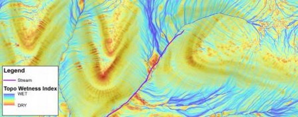
| Summary | The process described herein uses a type of digital terrain analysis (DTA) resulting in a Topographic Wetness Index (TWI) that quantifies topographic controls of basic hydrological processes. Upon completion, TWI raw output is displayed as a dimensionless linear color gradient, with starting and ending point colors based on the minimum and maximum flowpath intensities unique to each catchment. |
| Citation | Zimmerman, J. and J. Shallenberger (2016). GIS Topographic Wetness Index (TWI) Exercise Steps, 14 p. Accessed from: https://www.srbc.gov/pennsylvania-lidar-working-group/docs/twi-srbc.pdf |
| Read Time | 30 minutes - 1 hour |
| Author | Greggory Mirth, Eric Jespersen |
|---|---|
| Date | October 2016 |
| Summary | The technical companion piece to the overview document discussing Indiana University of Pennsylvania’s efforts towards data processing and creation. This is a more technical description of the work done. The central workflow in these papers is focused on flow accumulation as a means of deriving flow paths; however, this technical report provides more detail with regards to workflow and the computational tools utilized. Includes a brief discussion/comparison of geospatial software. |
| Citation | Mirth, G. and E. Jespersen (2016). Extracting Hydro Data from Multiple LiDAR Series: USGS Contracted Project (funding opportunity number USGS-15-FA-0516) and collaboration with Lancaster County, PaMAGIC, and Indiana University of Pennsylvania, 29 p. Accessed from: https://pamagic.org/sites/default/files/documents/Water Data/G15AC00516Technical Report_revised final_20161130.pdf |
| Read Time | 1.5 - 2 hours |
| Author | Eric Jespersen, Glenn Mohler, Robert E. Wilson |
|---|---|
| Date | October 2016 |
| Summary | A companion piece to the technical report discussing Indiana University of Pennsylvania’s efforts towards data processing and creation. This is a more general description of the work done with additional findings and recommendations for a statewide application. The central workflow in these papers is focused on flow accumulation as a means of deriving flow paths. |
| Citation | Jespersen, E., G. Mohler, and R. E. Wilson (2016). NHD Pilot Project for Lancaster County – Project Overview and Findings: USGS Contracted Project and Collaboration with Lancaster County, PAMAGIC, and Indiana University of Pennsylvania, 19 p. Accessed from: https://pamagic.org/sites/default/files/documents/Water Data/G15AC00516OverviewReport_revised final_20161110.pdf |
| Read Time | 45 minutes - 1 hour |
| Presenters | Eric Jespersen, Matt Mercurio, Ellen Fehrs |
|---|---|
| Date | January 2020 |
| Presenter | Ellen Fehrs |
|---|---|
| Date | January 2020 |
| Presenters | Mike Moore, Craig Ebersole |
|---|---|
| Date | January 2020 |
| Presenter | Steve Aichele |
|---|---|
| Date | January 2020 |
| Presenters | Andrew Brenner, Cathy Power, Mischa Hey |
|---|---|
| Date | January 2020 |
| Presenters | Jon Duncan, Emily Kerstetter, Taylor Blackman, Jonathan Chester |
|---|---|
| Date | January 2020 |
| Presenters | David Saavedra, Matt Baker |
|---|---|
| Date | January 2020 |
| Presenters | Roger Barlow, George Onyullo |
|---|---|
| Date | January 2020 |
| Presenter | Heather Manzo |
|---|---|
| Date | February 2020 |
| Presenter | Megan Guy |
|---|---|
| Date | February 2020 |
| Presenter | Claire Jordy |
|---|---|
| Date | February 2020 |
| Presenter | Brett Kelly |
|---|---|
| Date | February 2020 |
For additional information contact:
- Sean Lukacs [email protected]
- Matt Mercurio [email protected]