Vegetation Network
The Vegetation Application Network focuses on ways LiDAR data can be used to map different aspects of vegetation.
Example applications:
- Tree Canopy Coverage
- Tree Canopy Heights
- Vegetation/Biomass Density
- Forest Management & Planning
- Riparian Forest Buffers
- Viewsheds (with tree canopy incorporated)
- Serving out the LiDAR data as an LAS Datasets
- Analyzing vegetation using the LAS Dataset Toolbar in ArcMap
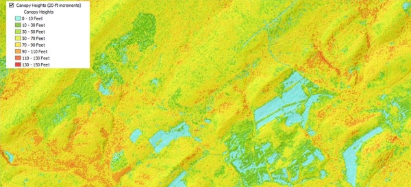
Forest canopy height calculated from LiDAR and used to identify poor, average, and superior sites for growing trees. Source: Brubaker, Johnson, Leites, 2014
Links:
- Practical LiDAR-Acquisition Considerations for Forestry Applications - Remote Sensing Applications Center
- ESRI Lidar Analysis in ArcGIS 9.3.1 for Forestry Applications - ESRI
- Forest Inventory Modeling - US Forest Service
- Lidar Acquisition Specifications for Forestry Applications - U.S. Forest Service
- Estimating Canopy Height of Deciduous Forests at a Regional Scale with Leaf-Off, Low Point Density LiDAR - K.M. Brubaker, S.E. Johnson, J. Brinks, L.P. Leites
- Mapping Vegetation Structure in the Pinaleno Mountains Using LiDAR - US Forest Service
- Mapping Vegetation Structure in the Pinaleno Mountains Using LiDAR Phase 3: Forest Inventory Modeling - US Forest Service
- Canopy Analysis in R using Forest Tools - Andrew Plowright
- Lidar-Derived Tree Canopy Heights Using ArcGIS Pro - PA Department of Conservation & Natural Resources, Bureau of Forestry
- Lidar-Derived Individual Tree Inventory Using ArcGIS Pro - PA Department of Conservation & Natural Resources, Bureau of Forestry
- Locating Downed Logs Beneath Forest Canopy Using Aerial Lidar - Keegan Flahive
Become a member of the network:
If you are interested in joining the Vegetation application network please complete the form below and and click the "Submit" button. Members of the network may be invited to attend conference calls or meetings and will be able to submit reference materials such as tools, code, scripts, papers, etc.
For additional information contact:
- Joe Petroski [email protected]